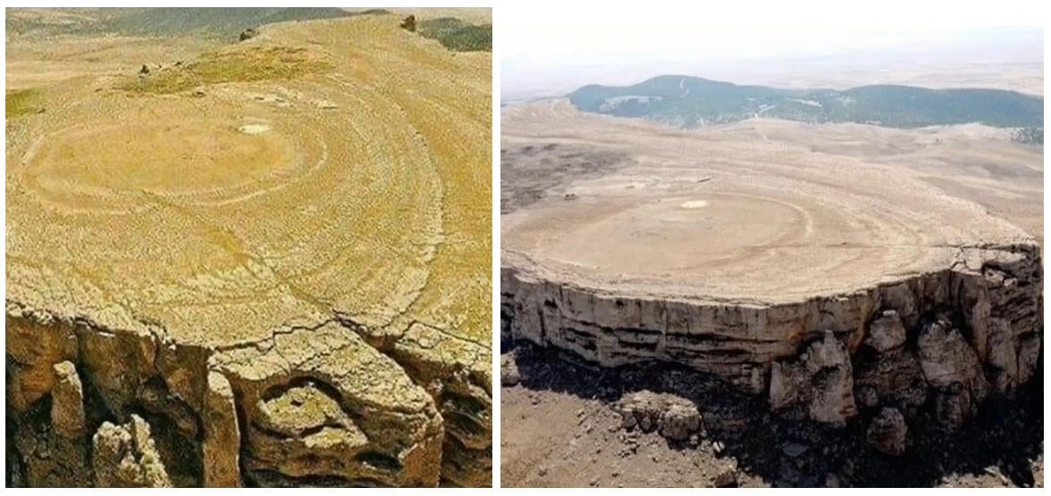
Do images described as tree stumps provide proof that there were once giant ancient trees which were felled by angels? No, that's not true: The photos show natural geological features around the world which came to be through several geological processes over millions of years. Volcanoes erupting, erosion of different materials at different speeds, and the lifting and folding of Earth's crust, sometimes produce textures that can resemble giant-scale bark, or growth rings, but these land forms are made of rock and were never a living tree. Scientists have calculated 122 - 130 meters as the maximum height a tree could ever grow.
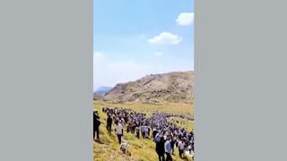
The slideshow of photos appears in a video (archived here) published on X by @TheDoctorRegen on Sept. 4, 2025. It was captioned:
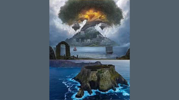
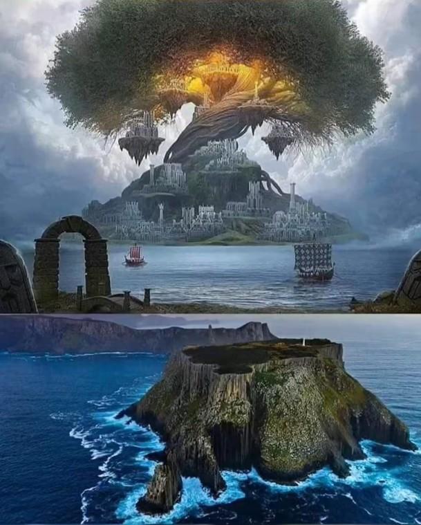
The Book of Enoch tells us why these massive trees were cut, and exactly who cut them.
This is how the video appeared at the time of writing:
(Image source: Lead Stories screenshot of post at x.com/TheDoctorRegen/status/1963802032566829295.)
The narration begins:
The book of Enoch describes exactly what happened to these giant ancient trees. Describes how these were cut down by the angels to flood the Nephilim. The Nephilim giants reaching 4,500 feet tall and I believe once these trees were felled the waters rushed out from below as the waters poured from above.
The scope of this fact check will not extend to the book of Enoch, its trees, or the mythological beings known as Nephilim. This fact check will identify the land forms pictured in the video and the geological processes which formed them.
In April 2004, the science journal Nature published a letter titled, "The limits to tree height". George W. Koch, a Professor of Biological Sciences at the University of Arizona, and colleagues in the biological and natural science fields predicted a maximum height attainable with calculations and reasoning they described in the abstract:
Our regression analyses of height gradients in leaf functional characteristics estimate a maximum tree height of 122-130 meters barring mechanical damage, similar to the tallest recorded trees of the past. As trees grow taller, increasing leaf water stress due to gravity and path length resistance may ultimately limit leaf expansion and photosynthesis for further height growth, even with ample soil moisture.
The scientist's tree height limit converts to a measurement of 400-426 feet. No trees have ever grown to 4,500 feet tall.
The 1 minute, 24 seconds @TheDoctorRegen video has 27 still images of geological formations. Some features are pictured more than once. Some features are from the same region, formed by the same processes. They will be grouped together here for clarity, but not necessarily in the order they appeared in the video.
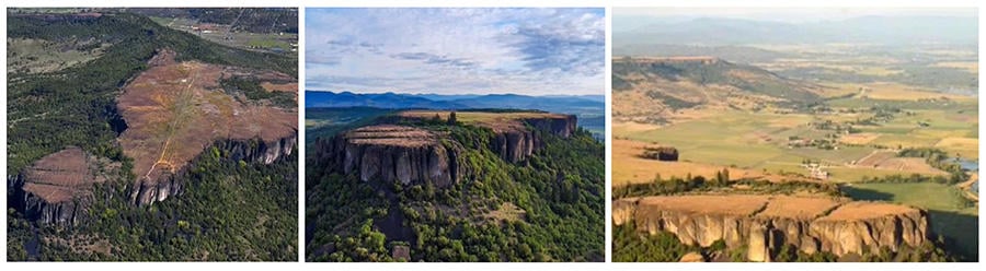
Jugurtha Tableland
Located in Tunisia. This is a plateau or large inverted relief mesa. The top surface of this table covers 80 hectares or almost 200 acres. The top is called a caprock and is composed of a hard sedimentary rock -- in this case, limestone, which formed millions of years ago when this area was at the bottom of a valley. Once it was formed, the limestone did not erode at the same speed as the surrounding land which has eroded away over millions of years.
The two photos included in the video were cropped to emphasise the circular pattern in the limestone surface -- while avoiding the shape of the entire landform, which when viewed in full, is not shaped like a tree stump. The Jugurtha Tableland was also featured in a fact check by Snopes debunking another "giant tree stump" story.
(Image Source: Lead Stories composite screenshot of post at x.com/TheDoctorRegen/status/1963802032566829295.)
Upper and Lower Table Rock
Located in Jackson County, Oregon near the Rogue River, the highest parts of the table rock formations were created by a lava flow during the Eocene Epoch over 34 million years ago. Similar to the Jugurtha Tableland, the flat-topped rock formations now stand high above the river valley landscape which was carved away by erosion. The Bureau of Land Management website has a detailed page explaining the natural history of this area.
(Image Source: Lead Stories composite screenshot of post at x.com/TheDoctorRegen/status/1963802032566829295.)
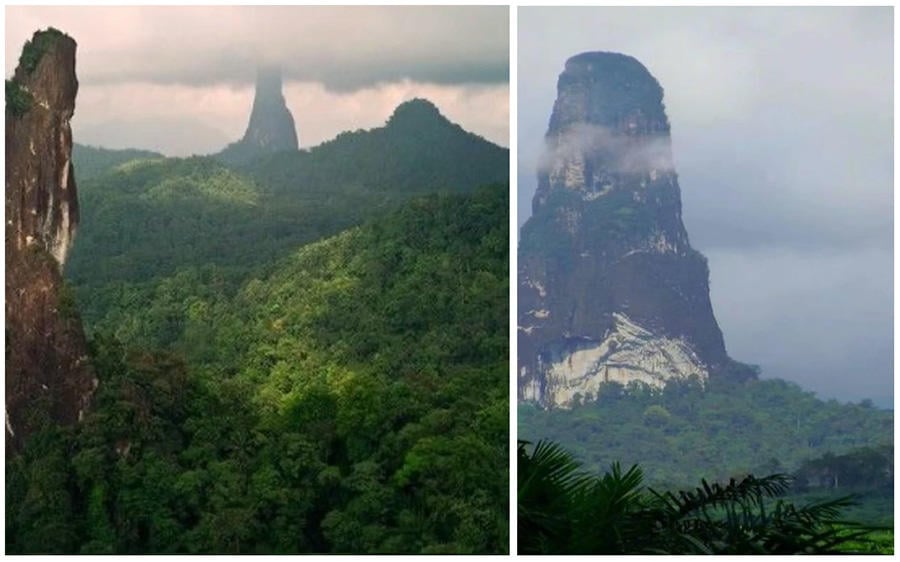
Pico Cão Grande
Located on the island nation São Tomé and Príncipe off the western coast of Africa. The entire island was formed by volcanic activity which is now dormant. The Pico Cão Grande is a volcanic plug. The website of the U.S. National Park service has a feature article on volcanic plugs including photos of examples which can be found in U.S. National parks, explaining:
Volcanic necks and plugs are the solidified remains of volcanoes' conduit and plumbing systems that remain after the rest of a volcano has been eroded away. Solidified conduits are usually more resistant to erosion than the surrounding volcanic edifice which may have consisted of loose tephra or hydrothermally altered rock.
(Image Source: Lead Stories composite screenshot of post at x.com/TheDoctorRegen/status/1963802032566829295.)
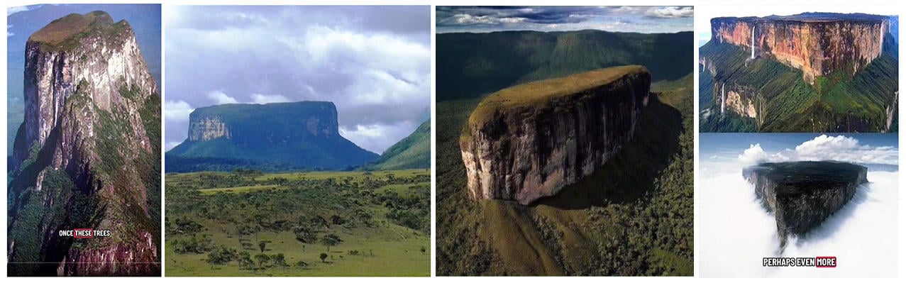
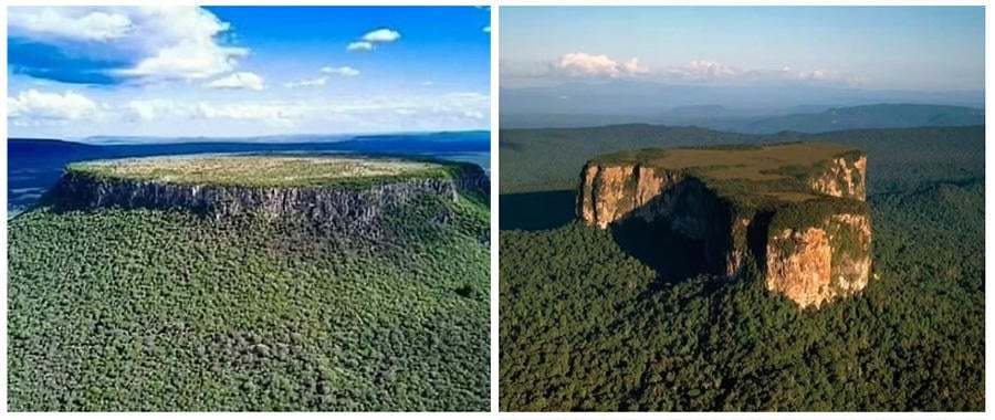
Cerro Autana, Apaurai Tepuy, and Mount Roraima
These are a type of table top mesa found in South America called a Tepui, meaning "house of the gods" in the language of the indigenous Pemón people of Venezuela. Canaima National Park in Venezuela, near the borders of Brazil and Guyana, covers an area of about 12,000 square miles and includes some of the Pacaraima Mountain range with more than thirty of these tabletop mesas. The area is part of the Guiana Shield (.pdf here). The present day landscape dates back to when a layer of sedimentary sandstone, 1.7 billion years old and a mile and a half thick was cracked and lifted by tectonic movements, and then eroded for hundreds of millions of years. The sheer rock walls of these Tepuis can be upwards of 3000 feet tall.
(Image Source: Lead Stories composite screenshot of post at x.com/TheDoctorRegen/status/1963802032566829295.)
Cerro de la Mesa Redonda and Ayangaik mountain
The image below left shows the quartzite Mesa Redonda in Lagos de Moreno, Jalisco, Mexico. Below right is a picture of Ayangaik Mountain. This is a tepui in the Pacaraima Mountains like those pictured above, but is in Guyana.
(Image Source: Lead Stories composite screenshot of post at x.com/TheDoctorRegen/status/1963802032566829295.)
Yahangala or "Bed Rock" near Kehelpothdoruwegala Mountain, Sigiriya -- "Lion Rock", and Danigala Circular Rock or "Alien Mountain"
These rock formations are in Sri Lanka. Yahangala (below left) is part of a mountain range named Knuckles. Sigiriya (below center) is a volcanic plug of hardened magma and was the site of a fifth century fortress which had a gate framed by the giant paws of a lion carved in the granite. The Danigala Circular Rock (below right) is a granite inselberg, an isolated land form that stands alone in its surroundings. Notably, Danigala contains petroglyphs, some carvings were only recently discovered during a survey in 2020.
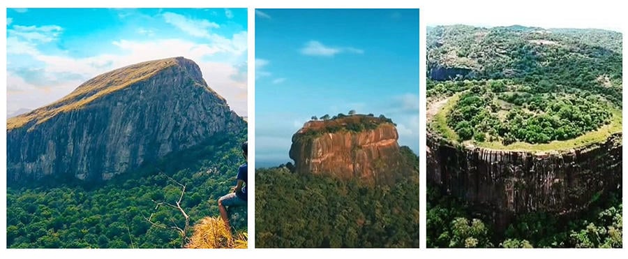
(Image Source: Lead Stories composite screenshot of post at x.com/TheDoctorRegen/status/1963802032566829295.)
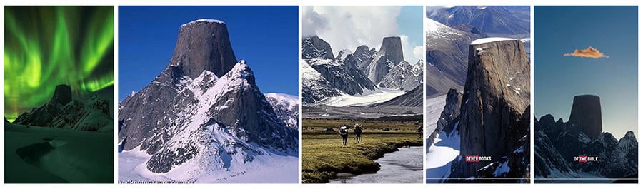
Mount Asgard
The five images below all show Mount Asgard, in the Baffin Mountains in Auyuittuq National Park, Nunavut Canada. This mountain range is part of the Canadian Shield. The mountain, a challenge for even the most experienced climbers, is composed of granite and has two cylindrical peaks which are connected by a saddle, examples of which are pictured in summitpost.org (archived here). None of the photos below show the mountain from that angle.
(Image Source: Lead Stories composite screenshot of post at x.com/TheDoctorRegen/status/1963802032566829295.)
The remaining five images (below) show features from around the world. From left to right they are:
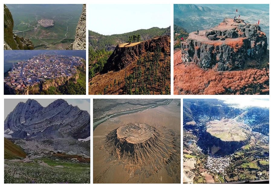
Amadiya
A town in Iraqi Kurdistan. The question of what formed the flat and almost circular plateau is not settled. In an scientific note in Vol.7, No.1, 2011 of the Iraqi Bulletin of Geology and Mining (.pdf download here) authors Varoujan K. Sissakian and Saffa F. Fouad put forth a new hypothesis to counter the existing belief that the plateau was the result of a large ancient landslide from the nearby mountains. They propose that it is made of calcrete, a sediment deposited by a river during the Late Pleistocene which later was mostly eroded.
Roque Margarita
This is an outcrop on Gran Canaria, Spain, one of the seven Canary Islands, a volcanic archipelago off the north western coast of Africa.
Kalavantin Durg
A basalt pinnacle located in the Western Ghats of Maharashtra, India. The landmark once served as a watchtower and fort, and has treacherous stairs carved into the steep rock sides.
(Image Source: Lead Stories composite screenshot of post at x.com/TheDoctorRegen/status/1963802032566829295.)
Katitsvera -- The Cat's Whiskers
This is a syncline fold in Racha, Georgia. Syncline describes that the layers of rock have folded like a U with the youngest layer of rock cradled in the center. The once-level sedimentary rock layers date back to the Jurassic and Early Cretaceous periods and were bent by tectonic inversion of an intercontinental rift which turned a basin into the fold and thrust belt of the Caucasus Mountains.
Guyot
The middle image above is a guyot in the Afar Depression in Ethiopia, Africa. Guyot is a geological term for a flat-topped underwater volcano and not the name of this specific landform which was at one time underwater. The geological history of the Afar Depression includes several faultlines which pulled apart with the pressure of magma from below; that faultline is where volcanoes formed.
Zaouia d'Ifrane
This is a town in Morocco (above right). The 200 foot tall plateau has caves and waterfalls and is composed of a type of limestone called travetine, a sedimentary rock which often forms around mineral springs.