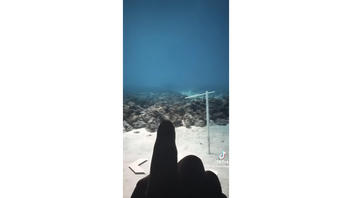
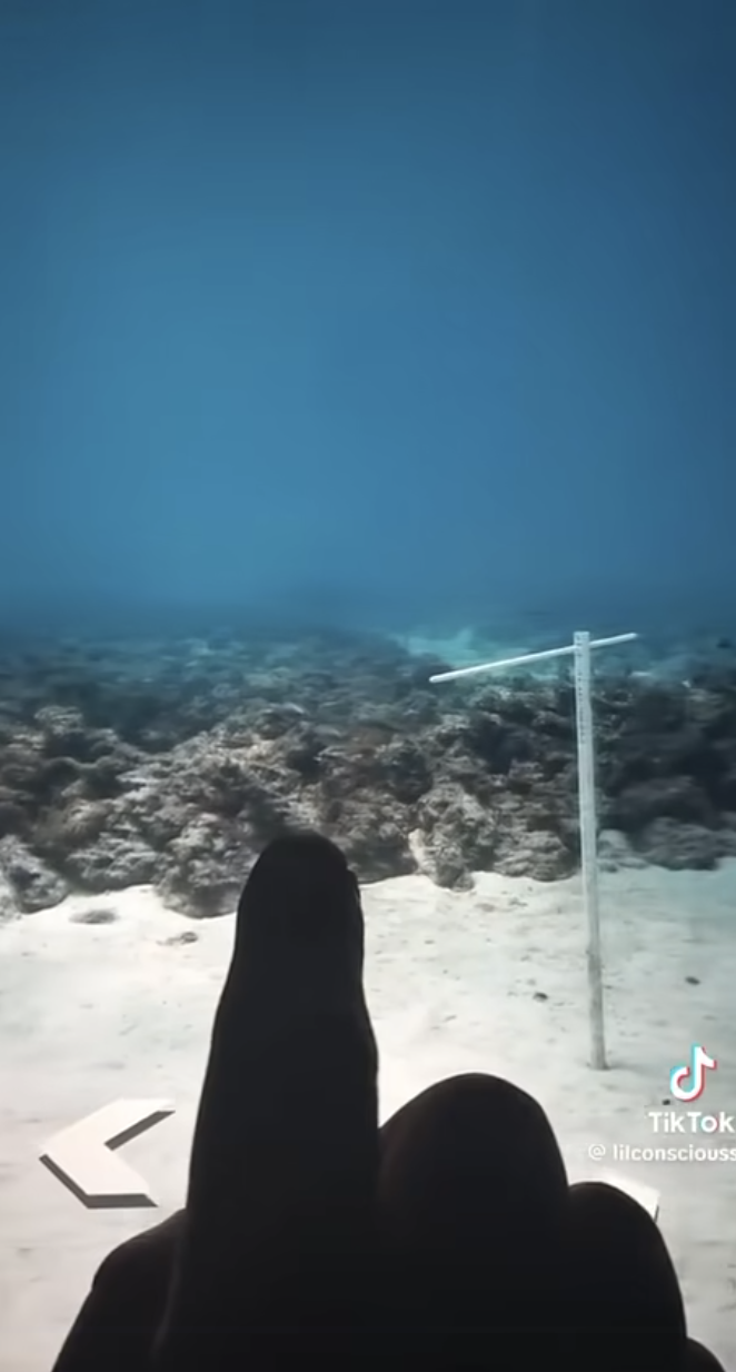
Does a video shared on Facebook genuinely show underwater HAARP devices surrounding Florida ahead of Hurricane Milton making landfall? No, that's not true: The video shows a coral restoration project in the Florida Keys, two marine scientists told Lead Stories. The antenna-like objects seen in the video are part of that coral reef rehabilitation project.
A version of the claim appeared in a video on Facebook on October 6, 2024, (archived here). The video, underscored by ominous-sounding music, opens with onscreen text reading, "What's hiding under the water in Florida?" In the video, a person zooms into satellite mapping data to eventually reveal divers and structures underwater off the Florida coast. A caption that accompanied the video reads:
HAARP is positioned perfectly right around Florida.
It does seem to be activated at as the whole state of Florida seems to be needing to prepare from wants to come.
Hopefully, this thing takes a turn, but please if you can try to get how to Florida or to go higher ground.
This video is very eye-opening and I had it for a while, but it just seem to hit me more after I have been watching hurricane Milton's path!
This is how the post appeared at the time of writing:
(Source: Facebook screenshot taken Tue Oct 8 14:40:00 2024 UTC)
The video claims -- without evidence -- that the objects shown are related to the High-frequency Active Auroral Research Program, or HAARP (archived here). HAARP is a scientific endeavor located in Alaska that studies the properties and behavior of the ionosphere. It does not manipulate or control the weather.
Rather, the clip shows coral reef rehabilitation systems, Joanna Walczak (archived here), a marine scientist at the Loggerhead Marinelife Center in Florida, told Lead Stories in an email on October 9, 2024.
These underwater 'street views' were a collaborative effort to showcase the underwater ecosystems that we are rapidly losing and how we are using restoration to slow the decline. By growing and outplanting baby corals while we work on reducing the stressors to the reef (like water quality pollution, climate change, etc.) we keep a living population of corals that will maintain the reef structure until conditions improve and they can thrive again.
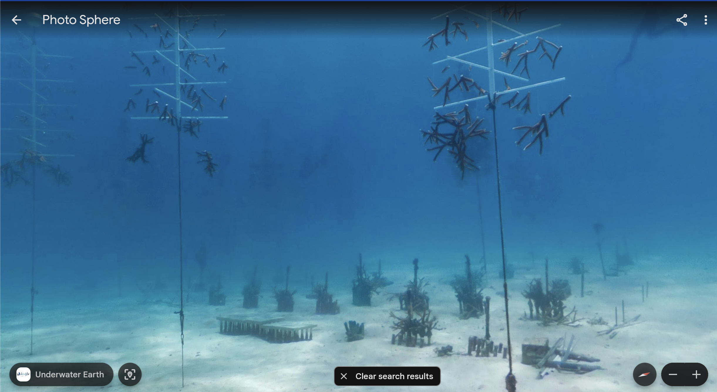
Walczak referred Lead Stories to several video clips that exhibit the type of work shown in the video on Facebook, published by Catlin Seaview Survey (archived here). The survey is described (archived here) as a "scientific study dedicated to creating a baseline record of the world's coral reefs in high-resolution 360-degree panoramic vision."
In an in-person interview on October 8, 2024, Hayley Drennon (archived here), a senior research assistant at Columbia University's Lamont-Doherty Earth Observatory (archived here), determined the video's latitude and longitude (24 degrees 58 minutes 54 seconds north, 80 degrees 26 minutes 10 seconds west). It shows the Snapper Ledge reef, located off the coast of Tavernier, Florida, visible on Google Earth.
This is a screenshot of the reef shown in Google Earth:
(Source: Google Earth screenshot taken Tue Oct 8 20:36:05 2024 UTC)
"Staghorn (Acropora cervicornis) corals are what you primarily see growing on the floating 'trees' and on most of the cement blocks. Although there are definitely some 'boulder' corals on the central blocks too," Walczak told Lead Stories.
Will Sautter, a marine scientist, told Lead Stories over text on October 8, 2024, that the video on Facebook shows a staghorn coral farm inside the Florida Keys Marine National Sanctuary (archived here). He wrote:
The researchers are cloning disease-resistant and climate-resilient corals in a lab, then taking them to the field station and suspending them in the water column using basic PVC stands with cement blocks. The clones will acclimate and grow in the wild through photosynthesis and filter-feeding plankton. Once they reach the appropriate size and conditions, the researchers can transplant them directly onto a degraded reef using a special nontoxic underwater cement.
Conspiracists have claimed HAARP is responsible for several natural events from earthquakes to the northern lights to controlling the direction of hurricanes.
Humans do not have any technology that can create, destroy, modify, intensify or steer hurricanes in any way, Howard Diamond (archived here), director of the Atmospheric Sciences and Modeling Division at NOAA's Air Resources Laboratory (archived here), told Lead Stories in an email received on October 8, 2024. He wrote:
Hurricanes Helene and Milton, like all hurricanes, formed on their own due to the right conditions of sea surface temperature and upper atmospheric winds. There is no technology that humans have that can either create, destroy, modify, intensify or steer hurricanes in any way, shape or form. HAARP, a small National Science Foundation-funded ionospheric research facility in Fairbanks, Alaska, is not engaged in weather modification. The HAARP system is basically a large radio transmitter. Radio waves interact with electrical charges and currents, and do not significantly interact with the troposphere. The claim in the link you noted to me is false.
Furthermore, satellite imagery like that used in Google Earth does not necessarily show the seafloor. Drennon added that images seen on Google Earth are intentionally added by people operating in such environments. She said:
There is a common misconception that Google satellites can directly visualize the seafloor. In reality, the satellites used for Google Earth function much like high-powered cameras--they capture images similar to what the human eye can see. This means they can't penetrate water beyond certain depths or water clarity.
The detailed seafloor features from the deep sea you see on Google Maps are based on publicly available maps that seafloor mapping scientists and researchers have carefully compiled and reviewed. Similarly, the public contributes to any photos you see from the ocean floor on Google Maps, much like the images of restaurants or landmarks you might find on Google Maps. You will also notice that this user has labels turned off, a feature you can easily select or deselect in the Desktop Application; if labels had been turned on, you would have instantly seen that this location is Snapper Reef Ledge.
As Lead Stories previously reported, hurricanes and other natural hazards are caused by Earth's natural marine and atmospheric factors. HAARP does not manipulate or control the weather, according to the HAARP website (archived here) under the heading "Environmental Effects" and subheading "Can HAARP Control or Manipulate the Weather?"?
Radio waves in the frequency ranges that HAARP transmits are not absorbed in either the troposphere or the stratosphere--the two levels of the atmosphere that produce Earth's weather. Since there is no interaction, there is no way to control the weather.
The HAARP system is basically a large radio transmitter. Radio waves interact with electrical charges and currents, and do not significantly interact with the troposphere .
Further, if the ionospheric storms caused by the sun itself don't affect the surface weather, there is no chance that HAARP can either. Electromagnetic interactions only occur in the near vacuum of the rarefied, but electrically charged, region of the atmosphere above about 60-80 km (a little over 45 miles), known as the ionosphere. The ionosphere is created and continuously replenished as the sun's radiation interacts with the highest levels of the Earth's atmosphere.
Other Lead Stories fact checks on claims related to hurricanes can be found here.