
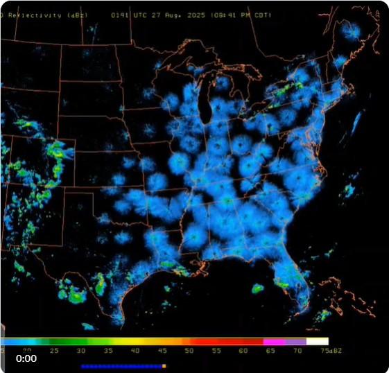
Does a blue pulse moving from east to west on a Doppler radar map show some sort of "storm pumping" weather modification or HAARP activity? No, that's not true: The radar reflectivity time lapse animation shows that radar signals have picked up the presence of millions of birds in flight who began their southward migration after the sun set. As darkness spread across the United States, the radar showed what looks like a pulse moving west. The birds are not present only in the areas where the blue spots appear, it's that they are only recorded as they fly within the reach of a station's Doppler radar beam.
The video appeared in a post (archived here) published on X by @RedpillDrifter on Aug. 26, 2025. It was captioned:
We're getting blasted. They are trying to pump the storm.
Text visible at the top of the video reads:
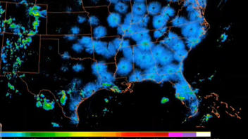
D Reflectivity (dBz) 2231 UTC 26 Aug. 2025 (05:31 PM CDT)
This is how the video appeared in the post at the time of writing:
(Image Source: Lead Stories screenshot of @RedpillDrifter post on X.)
Another post on X by @HustleBitch_ featured the same video (archived here) and this caption:
HAARP is absolutely frying the East Coast right now.
Does this look natural to you?
"HAARP" refers to the High-frequency Active Auroral Research Program, a radio wave transmitter in Alaska that is used to observe the Earth's upper atmosphere by measuring impacts of high-frequency radio waves on the ionosphere.
The radar time lapse, shown in the posts that are the subject of this fact check, takes about three seconds to show three hours of data, from 5:31 to 8:41 CDT. The footage loops four times in the twelve second video, giving the appearance of a blue wave pulsing from east to west.
There's a natural explanation for the regularity of the blue wave: The timing of the "arrival" of the wave in a specific area is directly correlated to the timing of the coming of night. Timeanddate.com allows users to look up the time of sunrise and sunset for a specific town on a certain date. For example, in Norfolk, Virginia on the Atlantic ocean, on Aug. 26, 2025 the sun set at 7:41 p.m. local time (6:41 CDT). While in Shreveport, Louisiana the sun set almost an hour later at 7:46 CDT. That tracks with the wave pattern.
In late September 2024 Lead Stories debunked several similar claims which surfaced after Hurricane Helene caused severe damage in many southeastern states (here and here). The radar images showed the same signature of migratory birds across the country, coinciding with the hurricane in the southeast. Some claimed incorrectly that the radar readings showed that HAARP had been used to steer the storm.
The website of the University of Fairbanks High-frequency Active Auroral Research Program (HAARP) answers whether it can influence the weather:
Can HAARP Control or Manipulate the Weather?
No. Radio waves in the frequency ranges that HAARP transmits are not absorbed in either the troposphere or the stratosphere--the two levels of the atmosphere that produce Earth's weather. Since there is no interaction, there is no way to control the weather.
The HAARP system is basically a large radio transmitter. Radio waves interact with electrical charges and currents, and do not significantly interact with the troposphere .
Further, if the ionospheric storms caused by the sun itself don't affect the surface weather, there is no chance that HAARP can either. Electromagnetic interactions only occur in the near vacuum of the rarefied, but electrically charged, region of the atmosphere above about 60-80 km (a little over 45 miles), known as the ionosphere. The ionosphere is created and continuously replenished as the sun's radiation interacts with the highest levels of the Earth's atmosphere.
The website of BirdCast, a program that monitors bird migration using weather radar, has a Weather Surveillance Radar and Bird Migration Primer that shows that weather is not the only thing picked up by weather radar. The central panel in the graphic below shows how the "passage migration" of birds appears as they fly through the range of a NEXRAD station (pictured below).
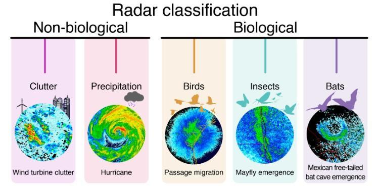
(Image Source: Lead Stories screenshot from birdcast.info.)
A live migration map can be found at birdcast.info. This Map has the radar stations noted, but the heatmap of the migration traffic is blended so the image more closely reflects the continuous flow of birds overhead. A red line represents sunset, and sweeps from east to west. The activity of the birds lags slightly behind with nocturnal migration starting about 30 minutes after sunset and peaking about two to three hours later.
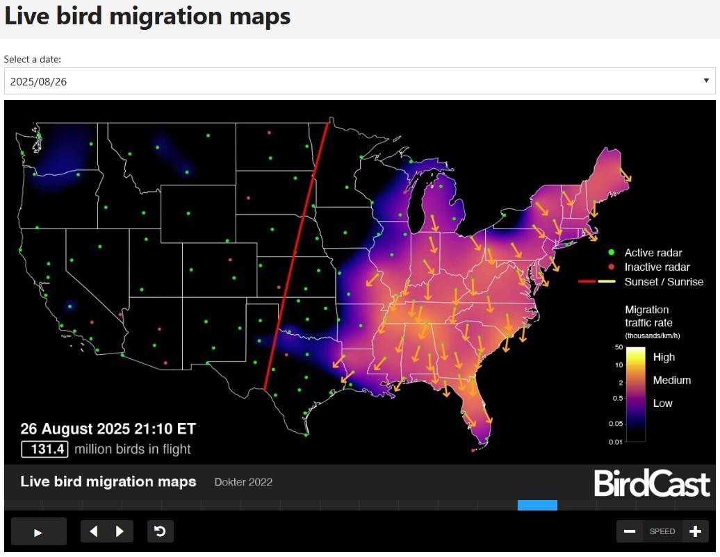
(Image Source: Lead Stories screenshot from Aug. 26, 2025 migration map on birdcast.info.)