Did a large plume of smoky air from Canada, which spread poor air quality conditions to many places in the U.S. in late June 2023, originate from gold and lithium mining operations in Sakami, Quebec, and not from forest fires? No, that's not true: There were many large and well-documented forest fires burning in the region near Sakami in northern Quebec, Canada, at the end of June 2023. The fires were recorded in satellite imagery as well as from monitoring stations on the ground, and they did not emanate from the specific mining complex identified in the video. The air quality index in the region measured dangerous levels for several days. Data provided by NASA's Fire Information for Resource Management System (FIRMS) shows hundreds of hotspots burning in the surrounding region of northern Quebec, but there was no heat register at the specific location where purported explosive mining activity occurred.
The video (archived here) was posted on TikTok on June 30, 2023, with this caption:
I mean I'm not saying anything besides... pay attention. Lithium is the new white gold? #canada #fire
This is what the post looked like on TikTok at the time of writing:
(Source: TikTok screenshot taken on Fri Jul 7 17:28:29 2023 UTC)
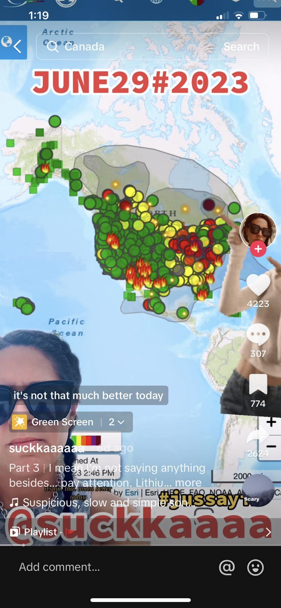
Although the caption says that she is not saying anything, the narrator does make some claims in the video. Showing a screenshot (pictured above) from the AirNow app from the U.S. Environmental Protection Agency (EPA) the narrator points out a "big purple blob in Canada." The map is zoomed out so far that the dots representing air monitoring stations are crowded together and overlap in the lower 48 states, but in sparsely populated northern Quebec, the one dot that is purple stands alone. The narrator goes on to suggest that the polluted air that has drifted over much of the eastern United States is the result of explosions during lithium mining operations.
The composite image below shows what the AirNow.gov website looks like on a desktop screen at the time of writing on July 7, 2023. These maps can be customized to display the monitoring stations (below left) or the contours (below right) of the zones of variations of the air quality index (AQI) or both. The map plays a 24-hour loop of the AQI Nowcast. To avoid obscuring most of the map most of the time -- the contours layer does not display green/good, but the monitoring stations with a good reading are represented by a green dot.
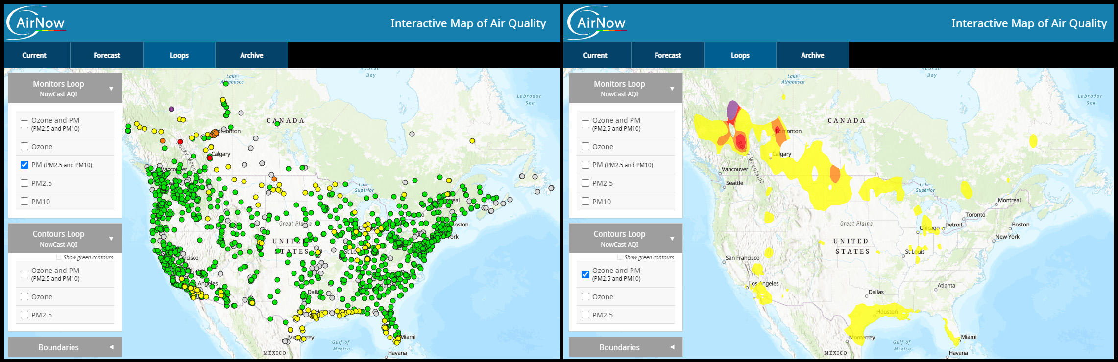
(Image source: Lead Stories composite image with gispub.epa.gov screenshots taken on Mon Jul 10 21:17:40 2023 UTC)
The AirNow.gov website also has archived data for each day. The screenshots (below) show zoomed out and zoomed in Daily AQI Monitors for June 29, 2023. The lone dark purple dot in northern Quebec shows in both screenshots. This is the location of a monitoring station. While the purple color of the dot does indicate "Very Unhealthy" air quality around the site, it is not meant to represent the point of origin of the bad air quality as the TikTok user suggests. Also visible is the large portion of the U.S. with unhealthy air quality ratings in red.
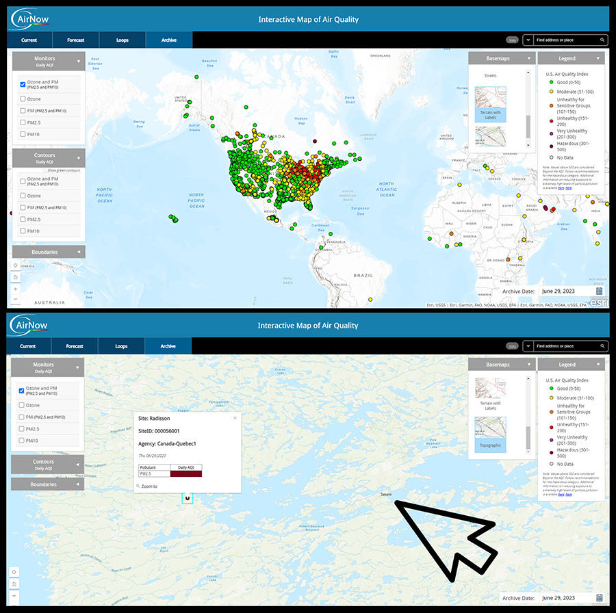
(Image source: Lead Stories composite image with gispub.epa.gov screenshots taken on Mon Jul 10 21:17:40 2023 UTC)
The narrator of this video says that after some investigating, her friend "Microsite" helped her figure out that it was Sakami. This is not correct. Lead Stories is unfamiliar with Microsite, but zooming in on the AirNow map shows this monitoring station Radisson (marked with the dark purple dot and blue square) is 64 miles across La Grande Riviere Reservoir from Sakami (marked with the black arrow). Clicking on the purple dot opens a pop-up window with details about the monitoring station.
Site: Radisson
SiteID: 000056001
Agency: Canada-Quebec1
Thu 06/29/2023
Pollutant PM2.5
Daily AQI 335
Lead Stories published a fact check about a claim from early June suggesting the forest fires in Quebec were coordinated because of the way they appeared to start all at once. Kyle Hilburn, a researcher at the Cooperative Institute for Research in the Atmosphere (CIRA), responded to Lead Stories' inquiry at that time, explaining in a June 8, 2023, email how that can happen:
I can confirm that our imagery shows a similar picture, around 14 UTC [Coordinated Universal Time] several fires blew up simultaneously. This is confirmed in terms of the smoke and the hot spots. However, rather than representing some sinister conspiracy, I think a more likely explanation is passage of a cold front ... . Certainly we've seen situations like this before, lightning from days before can start small areas that smolder for days and lack hot spots that can be seen by satellite, but then suddenly blow up into fires when stronger winds accompany a frontal passage. The timing of the cold front matches the fire blow up perfectly.
A similar situation happened in Quebec again at the end of June. Embedded below is a time-lapse satellite image from CIRA. The time-lapse shows a nearly simultaneous erupting of fires in the region surrounding Radisson and Sakami on June 29, 2023.
Yesterday's view of wildfires flaring up in Quebec.
-- CIRA (@CIRA_CSU) June 29, 2023
These fires are partly to blame for the horrible air quality across eastern North America. pic.twitter.com/3ILidUuPDh
The Lead Stories composite image below shows the Fire Information for Resource Management System (FIRMS) image from NASA including June 28 and 29, 2023. The zoomed-in inset shows the location of Sakami (circled in yellow) and that it was not involved with the active fires and hotspots that produced the smoke plume.
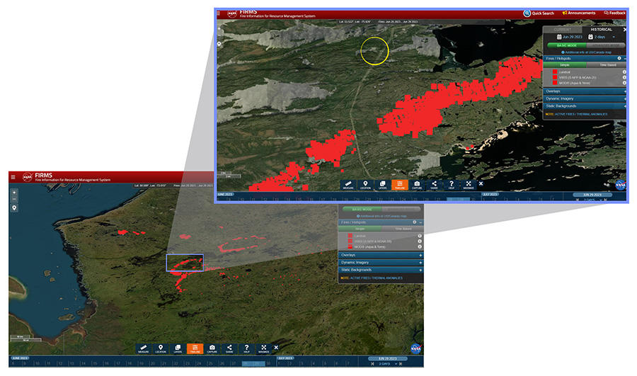
(Image source: Lead Stories composite image with NASA.gov screenshot taken on Fri Jul 07 21:17:40 2023 UTC)
Lead Stories reached out to the EPA and the Quebec Precious Metals Corporation for comment and will update this article if we receive a reply.