STORY UPDATED: check for updates below.
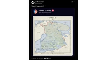
Did President-elect Donald Trump post a map of Finland on Truth Social? No, that's not true: A manual review of his account did not show such an entry as of this writing, January 14, 2025. The map in question did not correctly reflect current Finnish borders nor those in the year seen in the image.
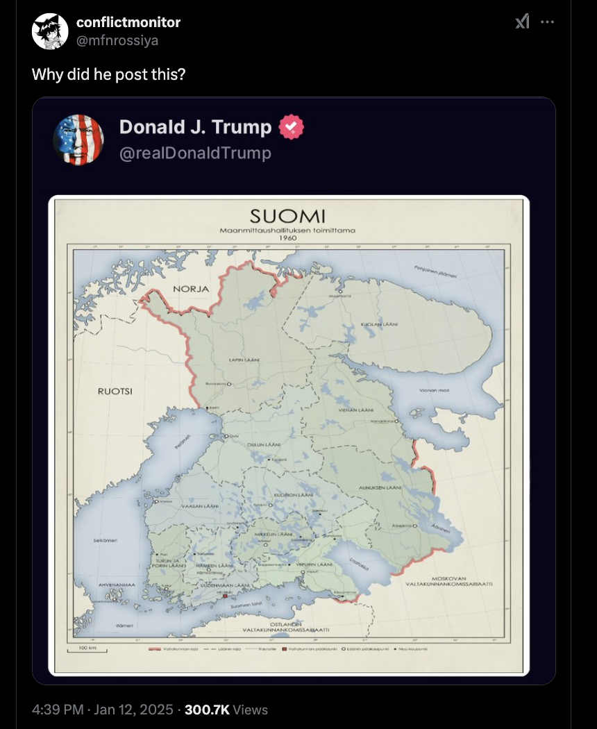
The claim appeared in a post (archived here) on X on January 12, 2025. It said:
Why did he post this?
The post shared a map titled:
SUOMI
As translated by Google Translate from Finnish, that word means:
Finland
This is what the post looked like on X at the time of writing:
(Source: X screenshot taken on Tue 15:44:19 2025 UTC)
The post
The claim reviewed in this article was posted in the aftermath of Trump's post-election statements concerning Canada (archived here), Greenland and the Panama Canal (archived here).
The red checkmark next to the account name in what looked like a screenshot of the supposed post was consistent with graphic elements on Trump's account on Truth Social.
Lead Stories manually reviewed January 2025 entries (archived here) on his account but found no map of Finland.
Textual searches for the words "Finland" (archived here) and "Suomi" (archived here) across Trump's posts on Truth Social produced no results, either.
A search across Trump's Truth -- a self-contained archive of Trump's "communications" on Truth Social -- produced a single result, but that was not a map of Finland as an individual state (archived here) and that post predated his re-election.
A search for the keywords seen here (archived here) across news reports on Google News published in the first 14 days of January did not show any journalistic articles corroborating the claim.
According to TrueMedia.org (archived here), the image of Trump's post could contain signs of generative AI.
The map
The supposed map of Finland from the post that is the focus of this fact check has been circulating (archived here) on social media platforms at least since July 18, 2019 (archived here).
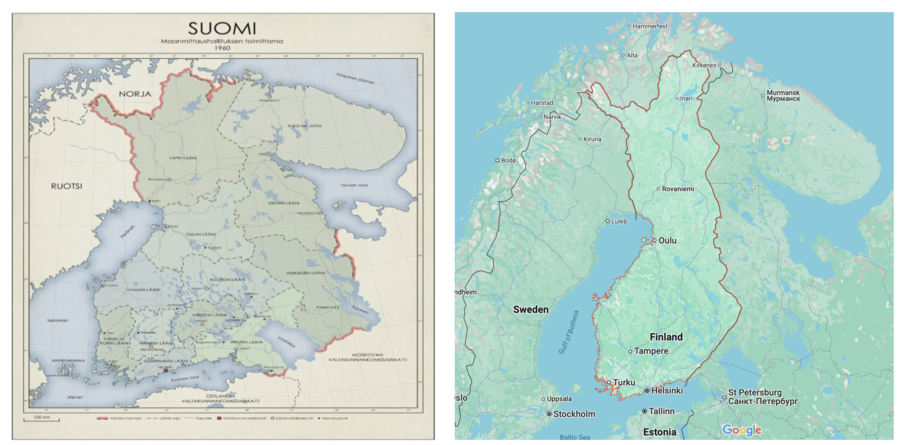
It does not accurately portray the borders of modern-day Finland.
The composite image below shows a side-by-side comparison between the map in question and Finland's state borders on Google Maps, as of this writing. The latter is consistent with maps on government websites in both the U.S. (archived here) and Finland (archived here):
(Sources: X screenshot taken on Tue 15:44:19 2025 UTC; Google Maps screenshot taken on Tue Jan 14 18:05:42 2025; composite image by Lead Stories)
The subheading in the map from the post on X linked its origin to the National Land Survey of Finland (archived here), implying that the country's official territory included the Kola Peninsula in 1960. The Kola Peninsula was part of the Soviet Union in 1960 and still is part of Russia, as of this writing.
A spokesperson for the National Land Survey of Finland told Lead Stories via email on January 15, 2025:
The map in the picture does not portray the borders of Finland in any point of history. It is indeed a fake map.
Read more
Other Lead Stories fact checks mentioning Donald Trump can be found here. Stories about the 2024 U.S. presidential election are here.
Updates:
-
2025-01-15T20:45:25Z 2025-01-15T20:45:25Z Adds quote from spokesperson for the National Land Survey of Finland.

