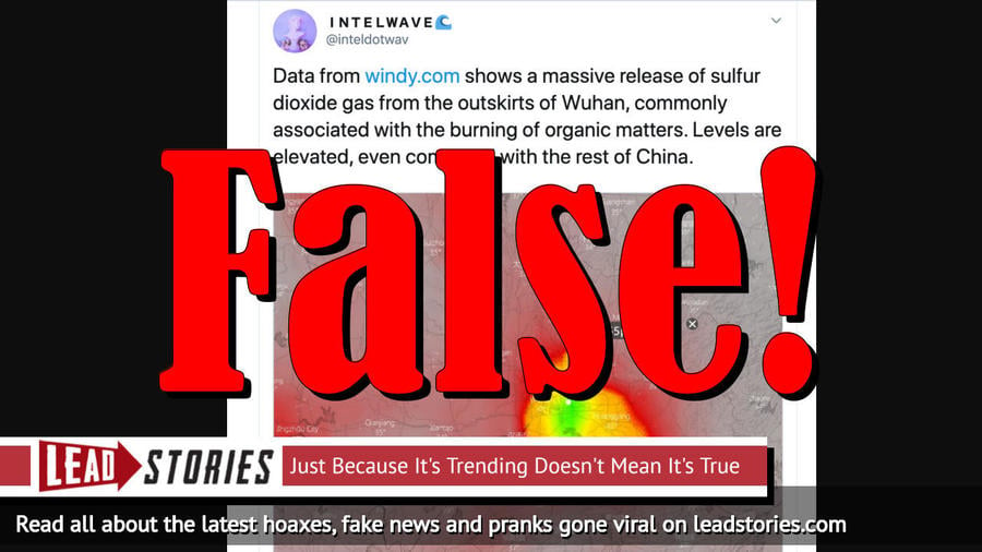
Does data from Windy.com show a massive release of sulfur dioxide gas near Wuhan, China, which is commonly associated with the burning of organic matters? No, that's not true: The images are not satellite measurements. A member of the NASA sulfur dioxide (SO2) team told Lead Stories that their satellite retrievals did not show significantly enhanced SO2 measurements over the region.
The claim originated from a series of tweets published by Intelwave (@inteldotwav) on February 8, 2020 (archived here). It opened:
Data from windy.com shows a massive release of sulfur dioxide gas from the outskirts of Wuhan, commonly associated with the burning of organic matters. Levels are elevated, even compared with the rest of China.
Users on social media only saw this:
INTELWAVE on Twitter
"Data from https://t.co/oDMad8pquE shows a massive release of sulfur dioxide gas from the outskirts of Wuhan, commonly associated with the burning of organic matters. Levels are elevated, even compared with the rest of China."
The image has been cited by several other websites and newspapers to suggest that bodies were being burned on a massive scale to control the novel coronavirus outbreak, which originated in Wuhan, China. As of February 18, 2020, the virus has killed at least 1,868 people, according to The New York Times.
And the third and most morbid: Dead bodies are being burned on the outskirts of the city, the death numbers are way higher than the CCP is letting on about, and things are really, really bad.
-- INTELWAVE🌊 (@inteldotwav) February 8, 2020
Lead Stories reached out to the NASA team in the Global Sulfur Dioxide Monitoring Personnel group. Dr. Nickolay Krotkov, a physical research scientist at the Goddard Space Flight Center, said:
The picture in the claim looks like model data and NOT satellite measurements.
He added:
We have checked and confirmed that our satellite retrievals do NOT show significantly enhanced SO2 signals over the region. The local air quality index (AQI) data from ground monitors in Wuhan do NOT show significantly enhanced SO2 readings over the past month.
We asked Krotkov to clarify the difference between model data and satellite measurements. He said:
Models forecast air quality based on meteorological weather forecast (predicted winds, temperatures, humidity, etc.) assuming KNOWN emissions of gases (NO2, SO2, etc.) and aerosols and chemical transformations models for different criteria pollutants (e.g., surface ozone, PM2.5).
Emissions inventories (SO2, NO2, etc.) are fixed, outdated and it takes years to compile and update them. Models cannot account for changes of pollutant EMISSIONS from day to day.
Satellite data show what gases and aerosols are actually measured at an overpass time over any cloud-free region. They are used to VERIFY model pollution forecasts.
In this case satellites do NOT see enhanced SO2 pollution over Wuhan region, which means that model SO2 emissions were not correct.
The suppositions from the original series of tweets have also been debunked by fullfact.org, which concluded that the images do not show evidence of mass cremations in Wuhan. It wrote:
False. The maps are not satellite images, and do not show actual levels of sulphur dioxide. They are simply forecasts based on historical data and weather patterns.
On February 12, 2020, Open, an Italian website, also rated the claim improbable. It quoted a chemistry professor from the University of Palermo who estimated it would take 30 million bodies to achieve the levels in the claim, which is simply impossible.
We wrote about disinformation on Twitter before. Here are our most recent articles that mention the site:
- Fake News: NO Obama Vacation Scam That President Trump Ended
- Fake News: NO Proof That High-Rise Buildings Have Become Human Incinerators To Combat Coronavirus
- Fake News: AOC Did NOT Propose $10.5B Cut To Social Security; Did NOT Say, "We Need To Sock It To The Boomers"
- Fake News: Photo Did NOT Show Pete Buttigieg Posing In Leather Bodysuit
- Fake News: State Of The Union Guests Were NOT Wearing "Q" Flag Pins


